Rock & Chips – Nag’s Head Location
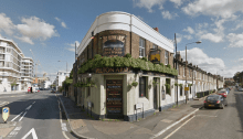
Location: The Pelton Arms, Pelton Road, London (The Nag’s Head) (More info) Google Maps Co-ordinates: 51.486795, 0.002406 Credit Extra: Trailer From: 2010 – 2011
Location: The Pelton Arms, Pelton Road, London (The Nag’s Head) (More info) Google Maps Co-ordinates: 51.486795, 0.002406 Credit Extra: Trailer From: 2010 – 2011

Location: Cairndhu House, Larne, County Antrim, Northern Ireland, UK (The House) Google Maps Co-ordinates: 54.893333, -5.847107 Extra: Official Trailer Tour Release: 02/09/2016 Director: Luke Scott Run Time: 92m Age Viewing: 15 Gross: $3,915,251

Locations: THE SIMPSONS – IN THE NAME OF THE GRANDFATHER (Season 20, Episode 14) Giant’s Causeway, Causeway Road, Bushmills (The result of a volcanic eruption – More info) Google Maps Co-ordinates: 55.240813, -6.511530 Blarney Castle, Cork, Ireland (Originally built in 1210 – More info) Google Maps Co-ordinates: 51.929124, -8.570902 Credit Release Date: 22/03/2009 Run Time:…
Locations: Missouriweg 25, 3199 LB Maasvlakte Rotterdam, Rotterdam, Netherlands (The Tent) Google Maps Co-ordinates: 51.942085, 4.036493 Koutoubia Mosque, Marrakesh, Morocco (Richard & James’ meeting point) Google Maps Co-ordinates: 31.623682, -7.993586 Credit Bentwaters Cold War Museum, Woodbridge, Suffolk (Car Battleships) Google Maps Co-ordinates: 52.131064, 1.432019 Atlas Mountains, Morocco (Jeremy drives the Alfa Romeo 4C) Google Maps Co-ordinates:…
Location: Arecibo Telescope, Puerto Rico 625, Arecibo, Puerto Rico (Built in early 1960’s – More info) Google Maps Co-ordinates: 18.344411, -66.752829 Credit Extra: Official Trailer Release: 17/11/1995 Director: Martin Campbell Run Time: 130m Age Viewing: 15 Gross: $106,429,941

Locations: 600 Pioneer Drive, Glendale, CA, United States (Callie’s Home) Google Maps Co-ordinates: 34.154574, -118.266905 679 N Kenilworth Ave, Glendale, CA, United States (The Tunnel) Google Maps Co-ordinates: 34.155449, -118.266726 Extra: Official Trailer Release: 11/04/2011 Director: Mike Flanagan Run Time: 87m Age Viewing: 15 Gross: N/A

A full, 3D version of The Eboladrome made with Sketchup. Taking around 1 week to complete using images and videos to create the track as accurate as possible. We hope you enjoy and please credit our work if you wish to share the images elsewhere. Address: Wroughton Airfield, Swindon, United Kingdom Download the Map HERE…

Locations: Fountains of Bellagio, South Las Vegas Boulevard, Las Vegas, NV, United States (More info) (View Map & Directions) Google Maps Co-ordinates: 36.112938, -115.174148 McCarran International Airport Las Vegas, Wayne Newton Boulevard, Las Vegas, NV, United States (Opened in 1920 – More info) Google Maps Co-ordinates: 36.099725, -115.163004 Fremont Hotel & Casino, Fremont Street, Las…
Locations: Benton Crossing, Mono County, California, USA (Fishing Scene) Google Maps Co-ordinates: 38.438245, -119.059691 6221 Painter Ave, Whittier, California, USA (Neighbor) (Built in 1905 – More info) Google Maps Co-ordinates: 33.985588, -118.032910 6232 Painter Avenue, Whittier, CA, United States (Sarah’s Home) Google Maps Co-ordinates: 33.985341, -118.032381 3077 E California Blvd, Pasadena, CA, United States (Mr…
Locations: Whitby, Yorkshire Norte, UK (The Grand Tour Tent) Google Maps Co-ordinates: 54.485310, -0.612980 Wroughton Airfield, Swindon, United Kingdom (The Grand Tour Test Track) (Built in 1940 – More info) Google Maps Co-ordinates: 51.513838, -1.795945 The River Usk, Wales, UK Google Maps Co-ordinates: 51.871767, -3.174843 The Bridge End Inn, Crickhowell, Wales, UK (Clarkson & Hammond…
