Exploring With Josh – Abandoned 737 Plane Location
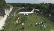
Location: Abandoned aircraft, Kutuh, Badung Regency, Bali, Indonesia Google Maps Co-ordinates: -8.832006, 115.187586 Credit Credit Official Video
Location: Abandoned aircraft, Kutuh, Badung Regency, Bali, Indonesia Google Maps Co-ordinates: -8.832006, 115.187586 Credit Credit Official Video

Location: Bedugul taman hotel, Batunya, Tabanan Regency, Bali, Indonesia Google Maps Co-ordinates: -8.298222, 115.176277 Official Video

Location: J.N. Adam Memorial Hospital, County Road 58, Perrysburg, NY, United States (The hospital catered for tuberculosis sufferers opened in 1909 up until it’s closure in 1995 – More Info) Google Maps Co-ordinates: 42.449333, -79.000658 View Image Official Video

“GOLD POINT Known originally as Lime Point, This area was first settled about 1880. The early camp was abandoned by 1882. In March 1908, a silver strike brought a new camp into existence. Called Hornsilver, it flourished for about a year, boasting about 800 residents, at least 11 saloons, a post office, telephone service and…
Location: Drive Thru Tree Park, Drive Thru Tree Rd, Leggett, CA, USA (A 276 foot high tree. With the hole measuring a width of 6ft, and a height of 6ft 9 – More Info) Google Maps Co-ordinates: 39.858675, -123.719073 Official Video
Location: Old Saint Francis School, Powhatan, VA, USA (The school was built in 1899 and closed in 1970; Serving as a school for young African-American women – More Info) Google Maps Co-ordinates: 37.618224, -77.977983 Want us to find another of Josh’s locations? Challenge us and send the video to our Submit Page Official Video
Location: Ape Cave, Cougar, WA, USA (Discovered in 1947 – More info) Google Maps Co-ordinates: 46.109540, -122.211393 Official Video
