Grumpy Old Men (1993) Film Locations


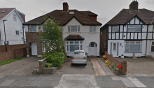
Locations: 1133 Hyacinth Avenue East, Payne – Phalen, Saint Paul, Ramsey County, Minnesota, United States (Gustafson’s House) (Built in 1914 – More info) Google Maps Co-ordinates: 44.980308, -93.052559 1122 Hyacinth Avenue East, Saint Paul, MN, United States (Ariel Truax’s House) (Built in 1918 – More info) Google Maps Co-ordinates: 44.979956, -93.052991 1137 Hyacinth Avenue East,…

Big Fat Liar Film Locations


Locations 992 S Oakland Ave, Pasadena, CA, United States (Jason’s House) (Built in 1916 – More info) Google Maps Co-ordinates: 34.128763, -118.139311 410 South Myrtle Avenue, Monrovia, CA, United States (Movie Theater) Google Maps Co-ordinates: 34.147688, -118.000654 101 Fremont Pl, Los Angeles, CA, United States (Clown Party Mansion) (Built in 1917 – More info) Google…

Mr. Deeds Film Locations


Locations: Public Art “Atlas”, 5th Avenue, New York, NY, United States (Built in 1937 by artist Lee Oscar Lawrie – More info) Google Maps Co-ordinates: 40.758943, -73.977202 31 Bank Street, New Milford, Connecticut, United States (Deed’s Pizza) Google Maps Co-ordinates: 41.577430, -73.411836 The Riverside Church, 490 Riverside Drive, Manhattan, New York, NY, United States (The…

Juno Film Locations


Locations: Eric Hamber Secondary School, Willow Street, Vancouver, British Columbia, Canada (Founded in 1962 – More info) Google Maps Co-ordinates: 49.239846, -123.125001 3691 West 36 Avenue, Vancouver, BC, Canada (Paulie Bleeker’s House) Google Maps Co-ordinates: 49.239789, -123.186655 4053 West 32 Avenue, Dunbar-Southlands, Vancouver, BC, Canada (Juno’s House) Google Maps Co-ordinates: 49.243627, -123.195414 Extra: Official Trailer…

Hairspray (2007) Film Locations


Locations: Lord Lansdowne Junior and Senior Public School, Robert Street, Toronto, Ontario, Canada (Patterson Park School – Tracy’s School) Google Maps Co-ordinates: 43.658892, -79.402140 Gale’s Snack Bar, 539 Eastern Avenue, Toronto, Ontario, Canada (Wilbur Turnblad’s Jokes & Magic Shop) Google Maps Co-ordinates: 43.658225, -79.339038 Tracy’s Home, next door to her father’s Jokes & Magic Shop…

The Whole Nine Yards (2000) Film Locations


Locations: 297 Rue Marcel Giguère, Blainville, Québec, Canada (Oz Oseransky House) Google Maps Co-ordinates: 45.654422, -73.812518 298-302 Rue Marcel Giguère, Blainville, QC, Canada (Jimmy Tudeski’s House) Google Maps Co-ordinates: 45.654686, -73.813136 Extra: Official Trailer Release: 18/02/2000 Director: Jonathan Lynn Run Time: 98m Age Viewing: 18 Gross: $57,262,492

Bend It Like Beckham Film Locations


Locations: 33 Sutton Square, Heston, West London (Jesminder ‘Jess’ Kaur Bhamra’s Home) (More info) Google Maps Co-ordinates: 51.478497, -0.375732 Yeading Football Club, Middlesex, England, UK (Hounslow Harriers practice pitch) Google Maps Co-ordinates: 51.508475, -0.394925 Molesey Football Club, Walton Road, West Molesey, Surrey, England, UK Google Maps Co-ordinates: 51.401460, -0.368133 Bara Hall Park, Hayes, Middlesex, England,…

The Little Rascals (1994) Film Locations


Locations: 1031 Figueroa Terrace, Los Angeles, CA, United States (The Clubhouse Location) Google Maps Co-ordinates: 34.069411, -118.245542 5320 Tujunga Avenue, North Hollywood, California, USA (Fire Department – “What’s the number for 911?”) Google Maps Co-ordinates: 34.167765, -118.378636  Venice Canals Walkway, Venice, Los Angeles, CA, United States (“You are so beautiful, to me”) Google Maps Co-ordinates:…

Big Momma’s House Film Locations


Locations: 1045 Figueroa Terrace, Echo Park, Los Angeles, California, USA (Sherry Pierce’s apartment) (Built in 1972 – More info) (Also seen in Nightcrawler) Google Maps Co-ordinates: 34.069409, -118.246049 Nibley Park, 1301 East Mountain Street, Glendale, California, USA (Basketball Game) Google Maps Co-ordinates: 34.164106, -118.238436 192 N Shaffer St, Orange, CA, United States (Big Momma’s House)…

Sister Act Film Locations


Locations: St. Paul’s Church, Church Street, Noe Valley, San Francisco, California, USA (Saint Christine’s Church) (Built in 1911 – More info) Google Maps Co-ordinates: 37.744214, -122.427271 50 S. Virginia Street, Reno, Nevada, USA (Police Station) Google Maps Co-ordinates: 39.524531, -119.811783 Nevada Club, Reno, Nevada, USA (Deloris performs in casino) Google Maps Co-ordinates: 39.526796, -119.812981 195…