Tag: mel gibson

  • Edge of Darkness (2010) Film Locations

    Edge of Darkness (2010) Film Locations

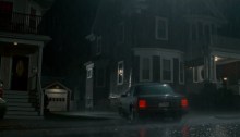
    Mel Gibson’s 2010 crime, thriller Edge of Darkness was filmed in and around the state of Massachusetts, with Boston being the primary location and Northampton for the courthouse scene. Locations: 68 Bradfield Ave, Boston, Massachusetts, USA (Thomas Craven’s Home) Google Maps Co-ordinates: 42.289798, -71.140378 I-90, Boston, MA 02127, USA Google Maps Co-ordinates: 42.346911, -71.063885 Location…

  • Bird on a Wire (1990) Film Locations

    Bird on a Wire (1990) Film Locations

    Filming locations for Mel Gibson & Holdie Hawn’s action, comedy was actually filmed in and around Victoria and Vancouver in British Columbia, Canada. As for Marvins Motown Motors where Rick worked, this location is unknown for now and may have been built specifically for the film as it gets engulfed in flames. Locations: Metropolitan Hotel…

  • What Women Want Film Locations

    What Women Want Film Locations

    Locations: 2400 North Lakeview Avenue, Chicago, Illinois, United States (Nick’s Apartment) (Built before 1980 – More info) Google Maps Co-ordinates: 41.925838, -87.639416 Rookery Building, South LaSalle Street, Chicago, IL, United States (Built in 1886 by architect Frank Lloyd Wright – More info) (Also used as ‘Duncan’s Toy Chest’ in Home Alone 2) (Nick & Darcy’s…

  • Braveheart Film Locations

    Locations: Glencoe, Scotland, UK Google Maps Co-ordinates: 56.682810, -5.102771 Loch Leven, Scotland, UK Google Maps Co-ordinates: 56.197115, -3.375998 Trim Castle, Co Meath, Ireland (Built in the 12th Century created by King Henry II of England – More Info) Google Maps Co-ordinates: 53.554401, -6.789399 Extra: Official Trailer Special Release: 24/05/1995 Director: Mel Gibson Run Time: 178m Age Viewing: 15 Gross: $75,609,945

  • Conspiracy Theory Film Locations

    Conspiracy Theory Film Locations

    Locations: Orpheum Theater 842 S. Broadway, Los Angeles, California, USA (Movie Theatre Freddy Shouts “BOMB!”) Google Maps Co-ordinates: 34.042607, -118.255382 Queensboro Bridge, Manhattan, New York City, New York, USA (Car Exchange) Google Maps Co-ordinates: 40.756756, -73.954256 Westchester Medical Center, Valhalla, New York, USA Google Maps Co-ordinates: 41.086708, -73.805887 Extra: Official Trailer Release: 08/08/1997 Director: Richard Donner Run Time: 135m Age Viewing: 15…

  • Lethal Weapon Film Locations

    Lethal Weapon Film Locations

    Locations: 700 E Ocean Blvd, Long Beach, CA 90802, USA (Beginning Scene – Suicide Jump) (Built in 1956 by architect Welton David Becket – More Info) Google Maps Co-ordinates: 33.765768, -118.184209 12000 Vista del Mar, Playa del Rey, CA 90293, USA (Riggs’ Trailer Home) Google Maps Co-ordinates: 33.916556, -118.427971 Emser Tile, Ruta Estatal de California 2, Los Angeles, CA,…